|
Ride
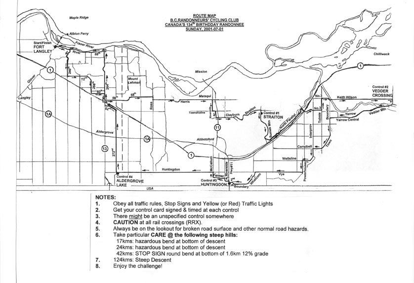
Results Canada Day 134 Populaire 134 km for 134 years Sunday, July 1 Start/Finish: Fort Langley Community Hall, Glover Road |
|
|
|
|
|
|
| 0 | L | N | Glover Road | 0.2 |
| 0.2 | R | E | Mavis St | 0.2 |
| 0.4 | BL | NE/E | River Rd (RRX) | 1.6 |
| 2 | R | S/W/S/W | 240th St / 88th Av / 240th St / Rawlinson Cres | 1.5 |
| 3.5 | L | S | 240th St | 2.4 |
| 5.9 | L | E/S/E | 72nd Av / 256th St (RRX)/60th Av | 7 |
| 12.9 | R | S | 264th St | 0.8 |
| 13.7 | L | E | 56th Av (RRX) / 58th Av / Interprovincial Hwy | 6.7 |
| 20.4 | R | S | Ross St (RRX) | 0.5 |
| 20.9 | L | E | Harris Rd (RRX) | 8.2 |
| 29.1 | R | S | Riverside Rd., Matsqui | 1.6 |
| 30.7 | L | E | Townshipline Rd | 0.5 |
| 31.2 | R | S | Riverside Rd | 0.8 |
| 32 | L | E | Clayburn Rd (X Hwy 11) thru Clayburn Village | 2.3 |
| 34.3 | BL | NE | Straiton Rd (avoid steep UP) / Dawson Rd | 4.7 |
| 39 | R | S | Upper Sumas Mountain Rd | 0.2 |
| 39.2 |
|
|||
| 39.2 | L | S | Upper Sumas Mtn Rd (12% Descent) | 3.4 |
| 42.6 | BL | SW | Lower Sumas Mtn Rd into Kilgard | 0.7 |
| 43.3 | L | SE | Indian Rd | 0.9 |
| 44.2 | L | NE | Eldridge Rd (parallel to Hwy #1) | 1.6 |
| 45.8 | R | S/NE | Atkinson Rd / North Parallel Rd | 4.5 |
| 50.3 | R | E | No. 3 Rd, (over Hwy #1) | 2.6 |
| 52.9 | L | N | Tolmie Rd | 1.5 |
| 54.4 | R | E/S | No. 2 Rd / Boundary Rd (no choice) | 1.3 |
| 55.7 | L | E | X Vedder Canal to Keith Wilson Rd (RRX) | 8.6 |
| 64.3 | R | S | Vedder Rd | 0.1 |
| 64.4 |
|
|||
| 64.4 | R | S/W | Vedder Rd x Bridge / Cultus Lk Rd to T/L | 1.5 |
| 65.9 | BR | W | Vedder Mtn Rd (RRX) / Yarrow Central Rd | 8.2 |
| 74.1 | L | S/W | Boundary Rd / Town Rd / Campbell Rd | 5.7 |
| 79.8 | L | S/W | Interprovincial Hwy / Wellsline Rd | 2.6 |
| 82.4 | L | S | Powerhouse Rd | 1.6 |
| 84 | R | W | Vye Rd | 6.4 |
| 90.4 | L | S | Whatcom Rd (RRX) / Boundary / 2nd St (RRX) | 4.7 |
| 95.1 |
|
|||
| 95.1 | R | N | Hwy # 11 | 0.3 |
| 95.4 | L | W | 4th St (RRX x 3) | 0.4 |
| 95.8 | R | N | Riverside Rd | 0.4 |
| 96.2 | L | W | Farmer Rd | 1.6 |
| 97.8 | R | N | McCallum Rd | 0.8 |
| 98.6 | L | W | Huntingdon Rd / 8th Av | 12.9 |
| 111.5 | R | N | 272nd St thru Aldergrove / 52nd Av | 10.1 |
| 121.6 | R | N | Hwy # 13 x Hwy # 1 / 264th St (Steep Descent) | 7.5 |
| 129.1 | L | W | 88th Av / River Rd (RRX) | 6.3 |
| 135.4 | R | W | Mavis St | 0.2 |
| 135.6 | L | S | Glover Rd | 0.2 |
| 135.8 |
|
|||
|
|
||||